|
|
Antenna Structure Registration 1003682 |
 |
Registration Info | Registration Number: 1003682 |
| File Number: A1378632 |
| FAA Study: 2002-AEA-4223-OE |
| FAA Issue Date: 02/04/2003 |
| Status: Constructed |
| Date Constructed: 01/30/2004 |
| FAA EMI: N |
| NEPA: N |
Structure Info
| Structure Type: TOWER |
| Structure Coordinates: 42-57-19.0 N 76-6-33.0 W (NAD 83) |
| Structure Coordinates: 42-57-18.8 N 76-06-34.3 W (Converted to NAD 27) |
| Structure Address: 3791 Sentinel Heights Rd |
| Structure City: La Fayette, NY |
| Structure County: Onondaga County |
| Painting & Lighting Info |
FAA Circular #: 70/7460-1K |
FAA Chapters: 3, 4, 5, 12 |
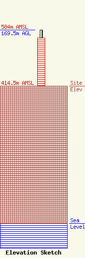
| Elevation Info |
Site Elevation: 414.5 meters (1360 ft) |
| Height of Structure: 146.3 meters (480 feet) |
| Overall Height Above Ground: 169.5 meters (556 feet) |
| Overall Height Above Mean Sea Level: 584 meters (1916 feet) |
| Owner Info | Deerfield Media (Syracuse), Inc.
573 E 840 S
Heber City, UT 84032
(435) 315-3047
dturner@manhanmedia.com |
| Contact Info | Pillsbury Winthrop Shaw Pittman LLP
1200 Seventeenth Street, NW
Washington, DC 20036
Scott Flick
(202) 663-8000
scott.flick@pillsburylaw.com |
