|
|
Antenna Structure Registration 1003920 |
 |
Registration Info | Registration Number: 1003920 |
| File Number: A0704982 |
| FAA Study: MKC-OE-67-17 |
| FAA Issue Date: 01/13/1969 |
| Status: Constructed |
| Date Constructed: 11/11/2010 |
| FAA EMI: N |
| NEPA: N |
Structure Info
| Structure Type: TOWER |
| Structure Coordinates: 38-28-56.0 N 90-23-53.0 W (NAD 83) |
| Structure Coordinates: 38-28-55.8 N 90-23-52.6 W (Converted to NAD 27) |
| Structure Address: 5489 Butler Hill Rd |
| Structure City: Saint Louis, MO |
| Structure County: St. Louis County |
| Painting & Lighting Info |
FCC Paragraph(s): 1, 3, 8, 17, 21 |
Remarks: RED LIGHTS/PAINT |
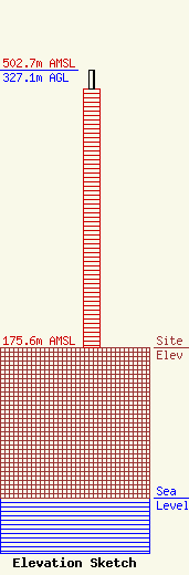
| Elevation Info |
Site Elevation: 175.6 meters (576 ft) |
| Height of Structure: 305.1 meters (1001 feet) |
| Overall Height Above Ground: 327.1 meters (1073 feet) |
| Overall Height Above Mean Sea Level: 502.7 meters (1649 feet) |
| Owner Info | St. Louis Regional Public Media Inc.
3655 OLIVE STREET
SAINT LOUIS, MO 63108
(314) 512-9000
|
| Contact Info | DOW LOHNES PLLC
1200 NEW HAMPSHIRE AVE NW, STE 800
WASHINGTON, DC 20036
TODD GRAY
(202) 776-2000
TGRAY@DOWLOHNES.COM |
