|
|
Antenna Structure Registration 1004116 |
 |
Registration Info | Registration Number: 1004116 |
| File Number: A1328262 |
| FAA Study: 2025-AEA-5800-OE |
| FAA Issue Date: 07/16/2025 |
| Status: Constructed |
| Date Constructed: 07/01/1998 |
| NEPA: N |
Structure Info
| Structure Type: GTOWER |
| Structure Coordinates: 40-51-18.2 N 72-46-9.0 W (NAD 83) |
| Structure Coordinates: 40-51-17.8 N 72-46-10.6 W (Converted to NAD 27) |
| Structure Address: Cr111 & Eastport Manor Rd (ny00467-a) |
| Structure City: Manorville, NY |
| Structure County: Suffolk County |
| Painting & Lighting Info |
FAA Circular #: 70/7460-1M |
FAA Chapters: 4, 8, 15 |
Remarks: PRIOR STUDY 2022-AEA-242-OE |
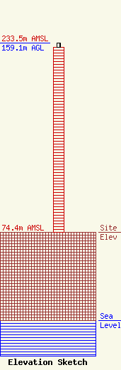
| Elevation Info |
Site Elevation: 74.4 meters (244 ft) |
| Height of Structure: 155.4 meters (510 feet) |
| Overall Height Above Ground: 159.1 meters (522 feet) |
| Overall Height Above Mean Sea Level: 233.5 meters (766 feet) |
| Owner Info | SBA Properties, LLC
8051 Congress Avenue
Boca Raton, FL 33487
(561) 995-7670
ERoach@sbasite.com |
| Contact Info | SBA Properties, LLC
8051 Congress Avenue
Boca Raton, FL 33487
(561) 995-7670
ERoach@sbasite.com |
