|
|
Antenna Structure Registration 1004577 |
 |
Registration Info | Registration Number: 1004577 |
| File Number: A1315338 |
| FAA Study: 2017-ACE-4626-OE |
| FAA Issue Date: 08/31/2017 |
| Status: Dismantled |
| Date Constructed: 10/10/2017 |
| NEPA: N |
Structure Info
| Structure Type: LTOWER |
| Structure Coordinates: 38-39-8.0 N 90-17-3.0 W (NAD 83) |
| Structure Coordinates: 38-39-07.8 N 90-17-02.6 W (Converted to NAD 27) |
| Structure Address: 532 Debaliviere Avenue |
| Structure City: Saint Louis, MO |
| Structure County: St. Louis city |
| Painting & Lighting Info |
FAA Circular #: 70/7460-1L |
FAA Chapters: 4, 8, 12 |
Remarks: PRIOR STUDY 2013-ACE-2172-OE |
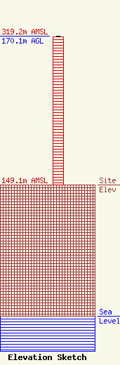
| Elevation Info |
Site Elevation: 149.1 meters (489 ft) |
| Height of Structure: 169.2 meters (555 feet) |
| Overall Height Above Ground: 170.1 meters (558 feet) |
| Overall Height Above Mean Sea Level: 319.2 meters (1047 feet) |
| Owner Info | Hubbard Radio St. Louis, LLC
3415 University Avenue, West
St. Paul, MN 55114-2009
(651) 642-4336
kshuldes@hbi.com |
| Contact Info | Wilkinson Barker Knauer, LLP
1800 M Street, N.W.
Washington, DC 20036
David O'Connor
(202) 383-3429
doconnor@wbklaw.com |
