|
|
Antenna Structure Registration 1004605 |
 |
Registration Info | Registration Number: 1004605 |
| File Number: A1382119 |
| FAA Study: 2026-ANM-1367-OE |
| FAA Issue Date: 03/17/2026 |
| Status: Constructed |
| Date Constructed: 07/01/1970 |
| NEPA: N |
Structure Info
| Structure Type: LTOWER |
| Structure Coordinates: 47-1-2.1 N 114-0-50.5 W (NAD 83) |
| Structure Coordinates: 47-01-02.4 N 114-00-47.1 W (Converted to NAD 27) |
| Structure Address: Tv Mountain 4 Miles East Of Evaro |
| Structure City: Missoula, MT |
| Structure County: Missoula County |
| Painting & Lighting Info |
FCC Paragraph(s): A1, H, 3, 11, 21, 23 |
Remarks: PRIOR STUDY 2026-ANM-1018-OE |
Remarks: Continue As Is OM&L = PAINT AND A MED-DUAL SYSTEM |
Remarks: PRIOR STUDY 2026-ANM-1018-OE |
Remarks: Continue As Is OM&L = PAINT AND A MED-DUAL SYSTEM |
| Elevation Info |
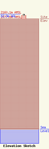
Site Elevation: 2077.8 meters (6817 ft) |
| Height of Structure: 64 meters (210 feet) |
| Overall Height Above Ground: 82.3 meters (270 feet) |
| Overall Height Above Mean Sea Level: 2160.1 meters (7087 feet) |
| Owner Info | Scripps Broadcasting Holdings LLC
312 Walnut Street
Cincinnati, OH 45202
(513) 977-3000
Bianca.Frye@scripps.com |
| Contact Info | The E.W. Scripps Company
312 Walnut Street
Cincinnati, OH 45202
Dave Giles
(513) 977-3000
David.Giles@scripps.com |
