|
|
Antenna Structure Registration 1004741 |
 |
Registration Info | Registration Number: 1004741 |
| File Number: A0550246 |
| FAA Study: 2006-AGL-9547-OE |
| FAA Issue Date: 01/09/2007 |
| Status: Constructed |
| Date Constructed: 05/21/2007 |
| FAA EMI: N |
| NEPA: N |
Structure Info
| Structure Type: TOWER |
| Structure Coordinates: 42-33-52.1 N 85-27-31.0 W (NAD 83) |
| Structure Coordinates: 42-33-52.0 N 85-27-31.0 W (Converted to NAD 27) |
| Structure Address: .4 Mi N Of Keller Rd., .3 Mi E Of Norris Rd. |
| Structure City: Orangeville Township, MI |
| Structure County: Barry County |
| Painting & Lighting Info |
FAA Circular #: 70/7460-1J |
FAA Chapters: 3, 4, 5, 13 |
Remarks: PRIOR STUDY 2006-AGL-9399-OE |
Remarks: Removed expiration date from determination. Scenario 1./jjs/case#635066 |
Remarks: OM&L to remain the same as prior study = PAINT/RED LIGHTS |
Remarks: Removed expiration date from determination. Scenario 1./jjs/case#635066 |
Remarks: OM&L to remain the same as prior study = PAINT/RED LIGHTS |
Remarks: PRIOR STUDY 2006-AGL-9399-OE |
| Elevation Info |
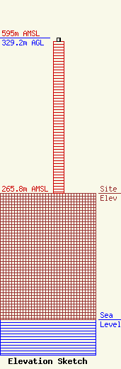
Site Elevation: 265.8 meters (872 ft) |
| Height of Structure: 321.3 meters (1054 feet) |
| Overall Height Above Ground: 329.2 meters (1080 feet) |
| Overall Height Above Mean Sea Level: 595 meters (1952 feet) |
| Owner Info | Christian Broadcasting Ministry
2397
Sandusky, OH 44870
(419) 684-5311
|
| Contact Info | Carl E. Smith Consulting Engineers
2324 N. Cleveland-Massillon Rd.
807
Bath, OH 44210-0807
Roy Stype
(330) 659-4440
|
