|
|
Antenna Structure Registration 1005407 |
 |
Registration Info | Registration Number: 1005407 |
| File Number: A0176207 |
| FAA Study: 89-AEA-0211-OE |
| FAA Issue Date: 03/28/1989 |
| Status: Constructed |
| Date Constructed: 05/01/1989 |
| FAA EMI: N |
| NEPA: N |
Structure Info
| Structure Type: TOWER |
| Structure Coordinates: 42-22-2.0 N 79-23-11.0 W (NAD 83) |
| Structure Coordinates: 42-22-01.8 N 79-23-11.8 W (Converted to NAD 27) |
| Structure Address: 0.6 Km S From Int Of Chaut Rd & Kelly Hill Rd Pomfret |
| Structure City: Fredonia, NY |
| Structure County: Chautauqua County |
| Painting & Lighting Info |
FAA Circular #: 70/7460-1G |
FAA Chapters: 3, 4, 5, 9 |
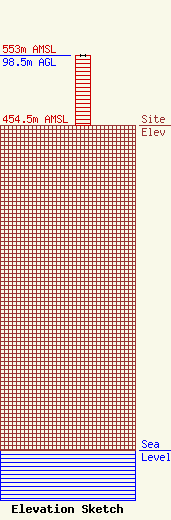
| Elevation Info |
Site Elevation: 454.5 meters (1491 ft) |
| Height of Structure: 97.5 meters (320 feet) |
| Overall Height Above Ground: 98.5 meters (323 feet) |
| Overall Height Above Mean Sea Level: 553 meters (1814 feet) |
| Owner Info | Chadwick Bay Broadcasting Corporation
45 Park Street
North East, PA 16428
(814) 725-2781
wzoo@aol.com |
| Contact Info | Carl E Smith Consulting Enginees
2324 N. Cleveland-Massillon Road
807
Bath, OH 44210
Roy Stype
(330) 659-4440
|
