|
|
Antenna Structure Registration 1005429 |
 |
Registration Info | Registration Number: 1005429 |
| File Number: A1385512 |
| FAA Study: 81-GL-654-OE |
| FAA Issue Date: 09/21/1981 |
| Status: Constructed |
| Date Constructed: 01/01/1981 |
| FAA EMI: N |
| NEPA: N |
Structure Info
| Structure Type: TOWER |
| Structure Coordinates: 42-28-3.0 N 84-39-6.0 W (NAD 83) |
| Structure Coordinates: 42-28-02.9 N 84-39-06.1 W (Converted to NAD 27) |
| Structure Address: 9447 Holmes Rd |
| Structure City: Eaton Rapids, MI |
| Structure County: Eaton County |
| Painting & Lighting Info |
FAA Circular #: 70/7460-1F |
FAA Chapters: 4, 7, 9 |
| Elevation Info |
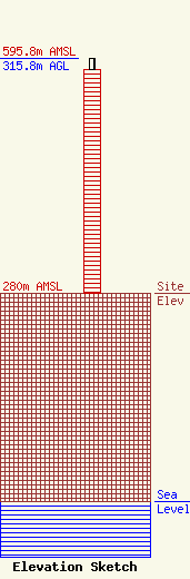
Site Elevation: 280 meters (919 ft) |
| Height of Structure: 301 meters (988 feet) |
| Overall Height Above Ground: 315.8 meters (1036 feet) |
| Overall Height Above Mean Sea Level: 595.8 meters (1955 feet) |
| Owner Info | Gray Local Media, Inc.
4370 Peachtree Road, NE
Atlanta, GA 30319
(404) 504-9828
allfcclms@gray.tv |
| Contact Info | Cooley LLP
1299 Pennsylvania Ave., NW
Washington, DC 20004
Henry Wendel
(202) 776-2943
hwendel@cooley.com |
