|
|
Antenna Structure Registration 1005722 |
 |
Registration Info | Registration Number: 1005722 |
| File Number: A0664906 |
| FAA Study: 99-AGL-3995-OE |
| FAA Issue Date: 10/15/1999 |
| Status: Constructed |
| Date Constructed: 03/01/1983 |
| FAA EMI: N |
| NEPA: N |
Structure Info
| Structure Type: TOWER |
| Structure Coordinates: 42-18-23.0 N 85-39-26.0 W (NAD 83) |
| Structure Coordinates: 42-18-22.9 N 85-39-26.0 W (Converted to NAD 27) |
| Structure Address: Nw Of Drake Rd & Sr M43 |
| Structure City: Kalamazoo, MI |
| Structure County: Kalamazoo County |
| Painting & Lighting Info |
FAA Chapters: NONE |
Remarks: PRIOR FAA 83-AGL-323-OE |
| Elevation Info |
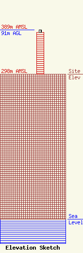
Site Elevation: 298 meters (978 ft) |
| Height of Structure: 86 meters (282 feet) |
| Overall Height Above Ground: 91 meters (299 feet) |
| Overall Height Above Mean Sea Level: 389 meters (1276 feet) |
| Owner Info | GRAND VALLEY STATE UNIVERSITY BOARD OF CONTROL
301 W FULTON
GRAND RAPIDS, MI 49504
(616) 331-6666
WALENTAM@GVSU.EDU |
