|
|
Antenna Structure Registration 1006703 |
 |
Registration Info | Registration Number: 1006703 |
| File Number: A1328170 |
| FAA Study: 2003-ASO-4390-OE |
| FAA Issue Date: 09/24/2003 |
| Status: Constructed |
| Date Constructed: 06/17/1991 |
| FAA EMI: N |
| NEPA: N |
Structure Info
|
| Structure Coordinates: 35-40-35.1 N 78-32-7.2 W (NAD 83) |
| Structure Coordinates: 35-40-34.5 N 78-32-08.2 W (Converted to NAD 27) |
| Structure Address: 5033 Tv Tower Rd |
| Structure City: Garner, NC |
| Structure County: Wake County |
| Painting & Lighting Info |
FAA Circular #: 70/7460-1G |
FAA Chapters: 4, 6, 9 |
Remarks: Continue As Is OM&L = 24-HR HI-STROBES |
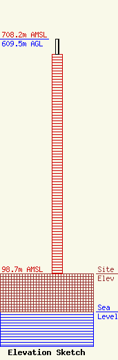
| Elevation Info |
Site Elevation: 98.7 meters (324 ft) |
| Height of Structure: 569.7 meters (1869 feet) |
| Overall Height Above Ground: 609.5 meters (2000 feet) |
| Overall Height Above Mean Sea Level: 708.2 meters (2323 feet) |
| Owner Info | Auburn Tower Partnership
2619 Western Blvd
Raleigh, NC 27606
(919) 890-6000
legal@capitolbroadcasting.com |
| Contact Info | Wilkinson Barker Knauer, LLP
1800 M Street, NW, Suite 800N
Washington, DC 20036
David O'Connor
(202) 383-3429
doconnor@wbklaw.com |
