|
|
Antenna Structure Registration 1006713 |
 |
Registration Info | Registration Number: 1006713 |
| File Number: A0787545 |
| FAA Study: 79-ASO-1000-OE |
| FAA Issue Date: 06/22/1979 |
| Status: Dismantled |
| Date Constructed: 01/01/1969 |
| FAA EMI: N |
| NEPA: N |
Structure Info
| Structure Type: TOWER |
| Structure Coordinates: 34-34-44.0 N 78-26-12.0 W (NAD 83) |
| Structure Coordinates: 34-34-43.4 N 78-26-13.0 W (Converted to NAD 27) |
| Structure Address: 1.1 Mi Se Of Lake Singletary Near N |
| Structure City: Colly Township, NC |
| Structure County: Bladen County |
| Painting & Lighting Info |
FCC Paragraph(s): 1, 3, 10.4, 19.4, 21 |
Remarks: RED LIGHTS/PAINT |
| Elevation Info |
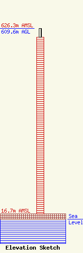
Site Elevation: 16.7 meters (55 ft) |
| Height of Structure: 580.8 meters (1906 feet) |
| Overall Height Above Ground: 609.6 meters (2000 feet) |
| Overall Height Above Mean Sea Level: 626.3 meters (2055 feet) |
| Owner Info | WECT, LLC
201 Monroe St., RSA Tower, 20th FL
Montgomery, AL 36104
(334) 206-1400
rbryan@raycommedia.com |
| Contact Info | Covington & Burling LLP
1201 Pennsylvania Avenue, NW
Washington, DC 20004
William Fitz
(202) 662-5120
wfitz@cov.com |
