|
|
Antenna Structure Registration 1006737 |
 |
Registration Info | Registration Number: 1006737 |
| File Number: A1182025 |
| FAA Study: 2017-ASW-17121-OE |
| FAA Issue Date: 11/22/2017 |
| Status: Constructed |
| Date Constructed: 09/01/1982 |
| NEPA: N |
Structure Info
| Structure Type: LTOWER |
| Structure Coordinates: 35-46-50.3 N 106-31-37.3 W (NAD 83) |
| Structure Coordinates: 35-46-50.2 N 106-31-35.2 W (Converted to NAD 27) |
| Structure Address: 9.3 Miles East Of Jemez Springs |
| Structure City: Jemez Springs, NM |
| Structure County: Sandoval County |
| Painting & Lighting Info |
FCC Paragraph(s): A1, H, 3, 11, 21, 23 |
Remarks: Continue As Is OM&L = A MED-DUAL SYSTEM |
Remarks: PRIOR STUDY 1983-ASW-2089-OE |
Remarks: Continue As Is OM&L = A MED-DUAL SYSTEM |
Remarks: PRIOR STUDY 1983-ASW-2089-OE |
| Elevation Info |
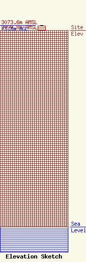
Site Elevation: 2999.8 meters (9842 ft) |
| Height of Structure: 72.5 meters (238 feet) |
| Overall Height Above Ground: 73.8 meters (242 feet) |
| Overall Height Above Mean Sea Level: 3073.6 meters (10084 feet) |
| Owner Info | American Towers LLC
10 Presidential Way
Woburn, MA 01801
(781) 926-4500
faa-fcc@americantower.com |
| Contact Info | American Towers LLC
10 Presidential Way
Woburn, MA 01801
(781) 926-4500
faa-fcc@americantower.com |
