|
|
Antenna Structure Registration 1007047 |
 |
Registration Info | Registration Number: 1007047 |
| File Number: A1122830 |
| FAA Study: 2016-ACE-3386-OE |
| FAA Issue Date: 08/18/2016 |
| Status: Constructed |
| Date Constructed: 08/29/1992 |
| NEPA: N |
Structure Info
| Structure Type: GTOWER |
| Structure Coordinates: 36-43-52.9 N 93-10-4.1 W (NAD 83) |
| Structure Coordinates: 36-43-52.7 N 93-10-03.5 W (Converted to NAD 27) |
| Structure Address: 0.75 Km Ne Of Hwy 160-hwy 176 Junction & 3.5 Km North Of Rockaway Beach. |
| Structure City: Rockaway Beach, MO |
| Structure County: Taney County |
| Painting & Lighting Info |
FAA Circular #: 70/7460-1H |
FAA Chapters: 4, 6, 13 |
Remarks: PRIOR STUDY 2001-ACE-1028-OE |
Remarks: OM&L to remain the same as prior study = 24-HR MED-STROBES |
Remarks: PRIOR STUDY 2001-ACE-1028-OE |
Remarks: OM&L to remain the same as prior study = 24-HR MED-STROBES |
| Elevation Info |
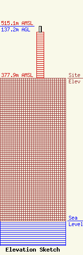
Site Elevation: 377.9 meters (1240 ft) |
| Height of Structure: 121.9 meters (400 feet) |
| Overall Height Above Ground: 137.2 meters (450 feet) |
| Overall Height Above Mean Sea Level: 515.1 meters (1690 feet) |
| Owner Info | Ozark Mountain Media Group, LLC
47 Patterson Avenue
Branson, MO 65616
(417) 337-5400
paulcoates2@gmail.com |
| Contact Info | Fletcher, Heald & Hildreth, PLC
1300 17th Street
Arlington, VA 22209
Stephen Lovelady
(703) 812-0517
lovelady@fhhlaw.com |
