|
|
Antenna Structure Registration 1007063 |
 |
Registration Info | Registration Number: 1007063 |
| File Number: A1342287 |
| FAA Study: 82-AEA-881-OE |
| FAA Issue Date: 01/01/1982 |
| Status: Constructed |
| Date Constructed: 01/01/1982 |
| FAA EMI: N |
| NEPA: N |
Structure Info
| Structure Type: TOWER |
| Structure Coordinates: 42-38-13.0 N 73-59-43.0 W (NAD 83) |
| Structure Coordinates: 42-38-12.7 N 73-59-44.5 W (Converted to NAD 27) |
| Structure Address: Beaverdam Rd |
| Structure City: New Scotland, NY |
| Structure County: Albany County |
| Painting & Lighting Info |
FAA Chapters: NONE |
| Elevation Info |
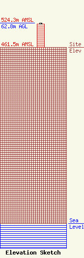
Site Elevation: 461.5 meters (1514 ft) |
| Height of Structure: 61 meters (200 feet) |
| Overall Height Above Ground: 62.8 meters (206 feet) |
| Overall Height Above Mean Sea Level: 524.3 meters (1720 feet) |
| Owner Info | VB-S1 Assets, LLC
22 W Atlantic Avenue
Delray Beach, FL 33444
(561) 406-4015
fcc-faa@verticalbridge.com |
| Contact Info | VB-S1 Assets, LLC
22 W Atlantic Avenue
Delray Beach, FL 33444
Richard Hickey
(561) 406-4015
fcc-faa@verticalbridge.com |
