|
|
Antenna Structure Registration 1007142 |
 |
Registration Info | Registration Number: 1007142 |
| File Number: A1322635 |
| FAA Study: 2015-AGL-16165-OE |
| FAA Issue Date: 11/23/2015 |
| Status: Constructed |
| Date Constructed: 01/01/1948 |
| NEPA: N |
Structure Info
| Structure Type: GTOWER |
| Structure Coordinates: 42-28-23.0 N 83-11-59.0 W (NAD 83) |
| Structure Coordinates: 42-28-22.9 N 83-11-59.3 W (Converted to NAD 27) |
| Structure Address: 15401 W 10 Mile Rd |
| Structure City: Oak Park, MI |
| Structure County: Oakland County |
| Painting & Lighting Info |
FAA Circular #: 70/7460-1K |
FAA Chapters: 4, 8, 12 |
Remarks: FAA CHAPTERS 4,8,12; 70/7460-1K WITH BIRD LIGHTING DEVIATION SPECIAL CONDITION. PRIOR STUDY 2015-AGL-13083-OE |
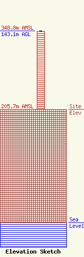
| Elevation Info |
Site Elevation: 205.7 meters (675 ft) |
| Height of Structure: 142 meters (466 feet) |
| Overall Height Above Ground: 143.1 meters (469 feet) |
| Overall Height Above Mean Sea Level: 348.8 meters (1144 feet) |
| Owner Info | Vertical Bridge CC FM, LLC
22 W Atlantic Ave Suite 310
Delray Beach, FL 33444
(561) 405-4015
fcc-faa@verticalbridge.com |
| Contact Info | Vertical Bridge CC FM, LLC
22 W Atlantic Ave Suite 310
Delray Beach, FL 33444
Richard Hickey
(561) 405-4015
fcc-faa@verticalbridge.com |
