|
|
Antenna Structure Registration 1007202 |
 |
Registration Info | Registration Number: 1007202 |
| File Number: A1075871 |
| FAA Study: N/A |
| Status: Constructed |
| Date Constructed: 02/16/1987 |
| NEPA: N |
Structure Info
| Structure Type: TOWER |
| Structure Coordinates: 39-24-54.0 N 92-24-37.0 W (NAD 83) |
| Structure Coordinates: 39-24-53.9 N 92-24-36.3 W (Converted to NAD 27) |
| Structure Address: 0.2 Km E Of Us Hwy 63 On Cty Hwy Ee |
| Structure City: Moberly, MO |
| Structure County: Randolph County |
| Painting & Lighting Info |
FCC Paragraph(s): 1, 3, 12, 21 |
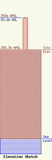
| Elevation Info |
Site Elevation: 259.7 meters (852 ft) |
| Height of Structure: 93.3 meters (306 feet) |
| Overall Height Above Ground: 93.3 meters (306 feet) |
| Overall Height Above Mean Sea Level: 353 meters (1158 feet) |
| Owner Info | Centennial Properties
1209 Paris Road
Mexico, MO 65265
(573) 721-1807
dewaynehfleming@gmail.com |
| Contact Info | Centennial Properties
1209 Paris Road
Mexico, MO 65265
(573) 721-1807
dewaynehfleming@gmail.com |
