|
|
Antenna Structure Registration 1007402 |
 |
Registration Info | Registration Number: 1007402 |
| File Number: A1265460 |
| FAA Study: 96-AGL-3410-OE |
| FAA Issue Date: 10/24/1996 |
| Status: Dismantled |
| Date Constructed: 06/01/1988 |
| FAA EMI: N |
| NEPA: N |
Structure Info
|
| Structure Coordinates: 45-20-50.0 N 84-58-1.0 W (NAD 83) |
| Structure Coordinates: 45-20-50.0 N 84-58-00.8 W (Converted to NAD 27) |
| Structure Address: 2095 Us Hwy 131 S |
| Structure City: Petoskey, MI |
| Structure County: Emmet County |
| Painting & Lighting Info |
FAA Circular #: 70/7460-1G |
FAA Chapters: 3, 4, 5, 9 |
| Elevation Info |
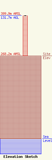
Site Elevation: 268.2 meters (880 ft) |
| Height of Structure: 130.8 meters (429 feet) |
| Overall Height Above Ground: 131.7 meters (432 feet) |
| Overall Height Above Mean Sea Level: 399.9 meters (1312 feet) |
| Owner Info | MacDonald Garber Broadcasting, Inc.
2095 U.S. 131 South
Petoskey, MI 49770
(231) 347-8713
tmac@106khq.com |
