|
|
Antenna Structure Registration 1007607 |
 |
Registration Info | Registration Number: 1007607 |
| File Number: A1383479 |
| FAA Study: 2012-ANM-844-OE |
| FAA Issue Date: 05/24/2012 |
| Status: Constructed |
| Date Constructed: 01/01/1994 |
| FAA EMI: N |
| NEPA: N |
Structure Info
| Structure Type: GTOWER |
| Structure Coordinates: 44-20-47.9 N 106-43-30.4 W (NAD 83) |
| Structure Coordinates: 44-20-48.0 N 106-43-28.2 W (Converted to NAD 27) |
| Structure Address: 1.3 Miles West Of Juncture Of I-25 And Us 16 |
| Structure City: Buffalo, WY |
| Structure County: Johnson County |
| Painting & Lighting Info |
FAA Circular #: 70/7460-1K |
FAA Chapters: 3, 4, 5, 12 |
Remarks: PRIOR STUDY 1994-ANM-817-OE |
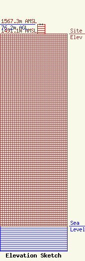
| Elevation Info |
Site Elevation: 1491.1 meters (4892 ft) |
| Height of Structure: 75.3 meters (247 feet) |
| Overall Height Above Ground: 76.2 meters (250 feet) |
| Overall Height Above Mean Sea Level: 1567.3 meters (5142 feet) |
| Owner Info | Iberlin Investments, LLC
50 East Loucks Street
5059
Sheridan, WY 82801
(307) 672-7444
blake@lonabaugh.com |
| Contact Info | Lonabaugh and Riggs, LLP
50 East Loucks Street
5059
Sheridan, WY 82801
Blake Godwin
(307) 672-7444
blake@lonabaugh.com |
