|
|
Antenna Structure Registration 1007622 |
 |
Registration Info | Registration Number: 1007622 |
| File Number: A0651594 |
| FAA Study: 2008-ANE-529-OE |
| FAA Issue Date: 08/01/2008 |
| Status: Granted |
| Date Constructed: 01/01/1985 |
| NEPA: N |
Structure Info
| Structure Type: TOWER |
| Structure Coordinates: 42-7-11.6 N 72-24-37.3 W (NAD 83) |
| Structure Coordinates: 42-07-11.3 N 72-24-39.0 W (Converted to NAD 27) |
| Structure Address: 190 Feet East Of 688 Ridge Rd - On Mt. Chapin |
| Structure City: Wilbraham, MA |
| Structure County: Hampden County |
| Painting & Lighting Info |
FAA Circular #: 70/7460-1K |
FAA Chapters: 4, 8, 12 |
Remarks: Removed expiration and final dates from determination. Scenario 2./jjs/case#635066 |
Remarks: PRIOR STUDY 2007-ANE-1341-OE |
Remarks: Removed expiration and final dates from determination. Scenario 2./jjs/case#635066 |
Remarks: PRIOR STUDY 2007-ANE-1341-OE |
| Elevation Info |
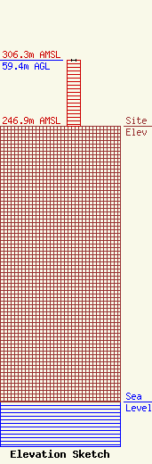
Site Elevation: 246.9 meters (810 ft) |
| Height of Structure: 59.4 meters (195 feet) |
| Overall Height Above Ground: 59.4 meters (195 feet) |
| Overall Height Above Mean Sea Level: 306.3 meters (1005 feet) |
| Owner Info | R and S Realty, LLC
29 Winthrop Street
Springfield, MA 01105
(860) 729-5991
SMinniti@cox.net |
| Info |
