|
|
Antenna Structure Registration 1007638 |
 |
Registration Info | Registration Number: 1007638 |
| File Number: A0841202 |
| FAA Study: 2013-ACE-1188-OE |
| FAA Issue Date: 06/06/2013 |
| Status: Constructed |
| Date Constructed: 01/01/1988 |
| FAA EMI: N |
| NEPA: N |
Structure Info
| Structure Type: GTOWER |
| Structure Coordinates: 37-9-52.9 N 93-23-45.8 W (NAD 83) |
| Structure Coordinates: 37-09-52.7 N 93-23-45.1 W (Converted to NAD 27) |
| Structure Address: 5431 West Sunshine |
| Structure City: Brookline Station, MO |
| Structure County: Greene County |
| Painting & Lighting Info |
FAA Circular #: 70/7460-1G |
FAA Chapters: 3, 4, 5, 9 |
Remarks: PRIOR STUDY 1988-ACE-51-OE |
Remarks: OM&L to remain the same as prior study = PAINT/RED LIGHTS |
Remarks: PRIOR STUDY 1988-ACE-51-OE |
Remarks: OM&L to remain the same as prior study = PAINT/RED LIGHTS |
| Elevation Info |
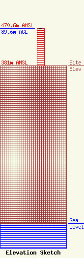
Site Elevation: 381 meters (1250 ft) |
| Height of Structure: 89.6 meters (294 feet) |
| Overall Height Above Ground: 89.6 meters (294 feet) |
| Overall Height Above Mean Sea Level: 470.6 meters (1544 feet) |
| Owner Info | Vision Communications, Incorporated
5431 West Sunshine
Brookline Station, MO 65619
(417) 831-0995
rcavision@gmail.com |
| Contact Info | Fletcher, Heald & Hildreth, PLC
1300 North 17th Street, 11th Floor
Arlington, VA 22209
Francisco Montero
(703) 812-0400
montero@fhhlaw.com |
