|
|
Antenna Structure Registration 1007673 |
 |
Registration Info | Registration Number: 1007673 |
| File Number: A1064555 |
| FAA Study: 2016-ANM-3328-OE |
| FAA Issue Date: 12/05/2016 |
| Status: Constructed |
| Date Constructed: 01/01/1978 |
| NEPA: N |
Structure Info
| Structure Type: GTOWER |
| Structure Coordinates: 45-45-37.0 N 108-27-11.0 W (NAD 83) |
| Structure Coordinates: 45-45-37.2 N 108-27-08.5 W (Converted to NAD 27) |
| Structure Address: On Sacrifice Cliff 4.7 Km Se Of Post Office |
| Structure City: Billings, MT |
| Structure County: Yellowstone County |
| Painting & Lighting Info |
FAA Chapters: NONE |
Remarks: PRIOR STUDY 1978-ANM-63-OE |
| Elevation Info |
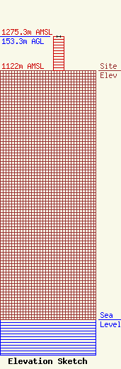
Site Elevation: 1122 meters (3681 ft) |
| Height of Structure: 152.4 meters (500 feet) |
| Overall Height Above Ground: 153.3 meters (503 feet) |
| Overall Height Above Mean Sea Level: 1275.3 meters (4184 feet) |
| Owner Info | CTI Towers Assets II, LLC
38 Pond Street
Franklin, MA 02038
(508) 440-5780
lstearns@ctitowers.com |
| Contact Info | CTI Towers Assets II, LLC
38 Pond Street
Franklin, MA 02038
Loren Stearns
(508) 440-5780
lstearns@ctitowers.com |
