|
|
Antenna Structure Registration 1007737 |
 |
Registration Info | Registration Number: 1007737 |
| File Number: A0009219 |
| FAA Study: 91-AEA-2250-OE |
| FAA Issue Date: 10/22/1992 |
| Status: Constructed |
| Date Constructed: 07/23/1997 |
| NEPA: N |
Structure Info
| Structure Type: TOWER |
| Structure Coordinates: 43-3-30.0 N 76-9-59.0 W (NAD 83) |
| Structure Coordinates: 43-03-29.8 N 76-10-00.3 W (Converted to NAD 27) |
| Structure Address: 401 W Kirkpatrick St |
| Structure City: Syracuse, NY |
| Structure County: Onondaga County |
| Painting & Lighting Info |
FAA Circular #: 70/7460-1H |
FAA Chapters: 3, 4, 5, 13 |
| Elevation Info |
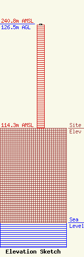
Site Elevation: 114.3 meters (375 ft) |
| Height of Structure: 125.6 meters (412 feet) |
| Overall Height Above Ground: 126.5 meters (415 feet) |
| Overall Height Above Mean Sea Level: 240.8 meters (790 feet) |
| Owner Info | WOLF RADIO INC
401 W KIRKPATRICK ST
SYRACUSE, NY 13204
(315) 468-0908
|
