|
|
Antenna Structure Registration 1007795 |
 |
Registration Info | Registration Number: 1007795 |
| File Number: A1170128 |
| FAA Study: 2003-AGL-6507-OE |
| FAA Issue Date: 11/25/2003 |
| Status: Constructed |
| Date Constructed: 02/16/2005 |
| FAA EMI: N |
| NEPA: N |
Structure Info
| Structure Type: TOWER |
| Structure Coordinates: 43-4-43.3 N 83-11-24.2 W (NAD 83) |
| Structure Coordinates: 43-04-43.2 N 83-11-24.4 W (Converted to NAD 27) |
| Structure Address: 4067 Haines |
| Structure City: Arcadia Township, MI |
| Structure County: Lapeer County |
| Painting & Lighting Info |
FAA Circular #: 70/7460-1K |
FAA Chapters: 4, 8, 12 |
Remarks: PRIOR STUDY 1983-AGL-541-OE |
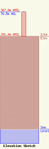
| Elevation Info |
Site Elevation: 291.4 meters (956 ft) |
| Height of Structure: 76 meters (249 feet) |
| Overall Height Above Ground: 76.5 meters (251 feet) |
| Overall Height Above Mean Sea Level: 367.9 meters (1207 feet) |
| Owner Info | Townsquare Media of Flint, Inc.
1 Manhattanville Road
Purchase, NY 10577
(203) 861-0900
fcccontact@townsquaremedia.com |
| Contact Info | Townsquare Media of Flint, Inc.
1 Manhattanville Road
Purchase, NY 10577
(203) 861-0900
fcccontact@townsquaremedia.com |
