|
|
Antenna Structure Registration 1007821 |
 |
Registration Info | Registration Number: 1007821 |
| File Number: A0630424 |
| FAA Study: 2006-AEA-2645-OE |
| FAA Issue Date: 06/28/2007 |
| Status: Constructed |
| Date Constructed: 04/07/2009 |
| FAA EMI: N |
| NEPA: N |
Structure Info
| Structure Type: TOWER |
| Structure Coordinates: 44-32-1.0 N 75-5-49.0 W (NAD 83) |
| Structure Coordinates: 44-32-00.8 N 75-05-50.3 W (Converted to NAD 27) |
| Structure Address: Waterman Hill 8 Km Se Of Canton Ny |
| Structure City: Russell, NY |
| Structure County: St. Lawrence County |
| Painting & Lighting Info |
FAA Circular #: 70/7460-1K |
FAA Chapters: 3, 4, 5, 12 |
Remarks: PRIOR STUDY 1988-AEA-1274-OE |
| Elevation Info |
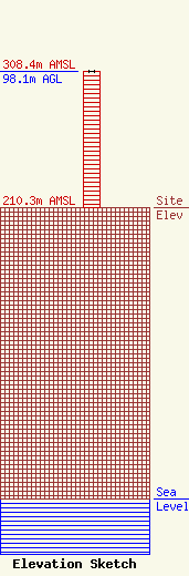
Site Elevation: 210.3 meters (690 ft) |
| Height of Structure: 98.1 meters (322 feet) |
| Overall Height Above Ground: 98.1 meters (322 feet) |
| Overall Height Above Mean Sea Level: 308.4 meters (1012 feet) |
| Owner Info | ST LAWRENCE UNIVERSITY DBA = NORTH COUNTRY PUBLIC RADIO
ST LAWRENCE UNIVERSITY
CANTON, NY 13617
(315) 379-5356
rsauter@stlawu.edu |
| Info |
