|
|
Antenna Structure Registration 1007944 |
 |
Registration Info | Registration Number: 1007944 |
| File Number: A1312331 |
| Status: Constructed |
| Date Constructed: 01/01/1965 |
| FAA EMI: N |
| NEPA: N |
Structure Info
|
| Structure Coordinates: 42-59-20.0 N 82-29-10.0 W (NAD 83) |
| Structure Coordinates: 42-59-19.9 N 82-29-10.3 W (Converted to NAD 27) |
| Structure Address: 2780 Beach Rd |
| Structure City: Port Huron, MI |
| Structure County: St. Clair County |
| Painting & Lighting Info |
FCC Paragraph(s): 1, 3, 11, 21 |
| Elevation Info |
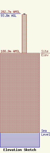
Site Elevation: 188.9 meters (620 ft) |
| Height of Structure: 91.5 meters (300 feet) |
| Overall Height Above Ground: 93.8 meters (308 feet) |
| Overall Height Above Mean Sea Level: 282.7 meters (927 feet) |
| Owner Info | New Tower, Inc.
808 HURON AVE
PORT HURON, MI 48060
(810) 982-9000
engineering@radiofirst.net |
| Contact Info | New Tower, Inc.
808 HURON AVE
PORT HURON, MI 48060
Sean Richardson
(810) 982-9000
engineering@radiofirst.net |
