|
|
Antenna Structure Registration 1008341 |
 |
Registration Info | Registration Number: 1008341 |
| File Number: A1351084 |
| FAA Study: 2015-AGL-13247-OE |
| FAA Issue Date: 10/19/2015 |
| Status: Constructed |
| Date Constructed: 03/01/1965 |
| NEPA: N |
Structure Info
| Structure Type: GTOWER |
| Structure Coordinates: 41-32-6.6 N 88-3-16.0 W (NAD 83) |
| Structure Coordinates: 41-32-06.5 N 88-03-15.8 W (Converted to NAD 27) |
| Structure Address: 601 Walnut Street, Joliet, Il |
| Structure City: Joliet, IL |
| Structure County: Will County |
| Painting & Lighting Info |
FCC Paragraph(s): 1, 3, 12, 21 |
Remarks: PRIOR STUDY 1998-AGL-2096-OE. OM&L to remain the same as prior study = PAINT/RED LIGHTS with grandfathered lighting levels per FCC Paragraphs 1, 3, 12, 21 |
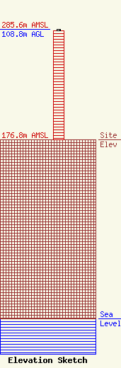
| Elevation Info |
Site Elevation: 176.8 meters (580 ft) |
| Height of Structure: 107.8 meters (354 feet) |
| Overall Height Above Ground: 108.8 meters (357 feet) |
| Overall Height Above Mean Sea Level: 285.6 meters (937 feet) |
| Owner Info | Vertical Bridge S3 Assets, LLC
22 W Atlantic Avenue
Delray Beach, FL 33444
(561) 406-4015
fcc-faa@verticalbridge.com |
| Contact Info | Vertical Bridge S3 Assets, LLC
22 W Atlantic Avenue
Delray Beach, FL 33444
Richard Hickey
(561) 406-4015
fcc-faa@verticalbridge.com |
