|
|
Antenna Structure Registration 1008380 |
 |
Registration Info | Registration Number: 1008380 |
| File Number: A1116057 |
| FAA Study: 2010-AGL-960-OE |
| FAA Issue Date: 04/06/2010 |
| Status: Constructed |
| Date Constructed: 01/01/1951 |
| FAA EMI: N |
| NEPA: N |
Structure Info
| Structure Type: TOWER |
| Structure Coordinates: 41-13-36.2 N 89-56-5.5 W (NAD 83) |
| Structure Coordinates: 41-13-36.1 N 89-56-05.1 W (Converted to NAD 27) |
| Structure Address: Beacon & Garfield Sts |
| Structure City: Kewanee, IL |
| Structure County: Henry County |
| Painting & Lighting Info |
FCC Paragraph(s): 1, 3, 11, 21 |
Remarks: Continue As Is OM&L = PAINT/RED LIGHTS |
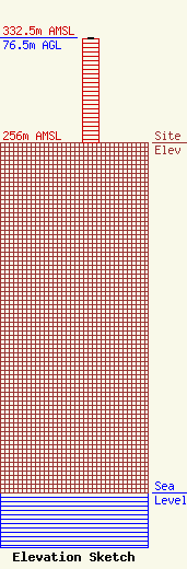
| Elevation Info |
Site Elevation: 256 meters (840 ft) |
| Height of Structure: 75.5 meters (248 feet) |
| Overall Height Above Ground: 76.5 meters (251 feet) |
| Overall Height Above Mean Sea Level: 332.5 meters (1091 feet) |
| Owner Info | Virden Broadcasting Corp.
307
Blue Grass, IA 52726
(563) 381-3999
ceo@regionalmedia.info |
| Contact Info | Virden Broadcasting Corp.
307
Blue Grass, IA 52726
Fletcher Ford
(563) 381-3999
ceo@regionalmedia.info |
