|
|
Antenna Structure Registration 1008520 |
 |
Registration Info | Registration Number: 1008520 |
| File Number: A1171015 |
| FAA Study: 2002-AGL-3108-OE |
| FAA Issue Date: 02/12/2004 |
| Status: Granted |
| Date Constructed: 08/02/2004 |
| NEPA: N |
Structure Info
| Structure Type: GTOWER |
| Structure Coordinates: 40-5-32.0 N 81-17-18.0 W (NAD 83) |
| Structure Coordinates: 40-05-31.8 N 81-17-18.6 W (Converted to NAD 27) |
| Structure Address: 3.8 Mi. N.w. Of Fairview , Oh On Plagah Church Road |
| Structure City: Fariview, OH |
| Structure County: Guernsey County |
| Painting & Lighting Info |
FAA Circular #: 70/7460-1K |
FAA Chapters: 3, 4, 5, 12 |
Remarks: OM&L TO REMAIN PAINT RED LIGHTS |
Remarks: Removed expiration date from determination. Scenario 1./jjs/case#635066 |
Remarks: OM&L TO REMAIN PAINT RED LIGHTS |
Remarks: Removed expiration date from determination. Scenario 1./jjs/case#635066 |
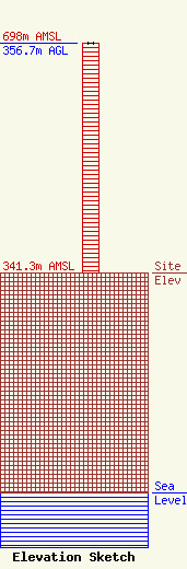
| Elevation Info |
Site Elevation: 341.3 meters (1120 ft) |
| Height of Structure: 356.7 meters (1170 feet) |
| Overall Height Above Ground: 356.7 meters (1170 feet) |
| Overall Height Above Mean Sea Level: 698 meters (2290 feet) |
| Owner Info | OHIO UNIVERSITY TELECOM. CENTER
9 SOUTH COLLEGE STREET
ATHENS, OH 45701
(614) 593-1771
brewer@ohio.edu |
| Contact Info | OHIO UNIVERSITY TELECOM. CENTER
9 SOUTH COLLEGE STREET
ATHENS, OH 45701
Steve Skidmore
(614) 593-1771
skidmore@ohio.edu |
