|
|
Antenna Structure Registration 1008865 |
 |
Registration Info | Registration Number: 1008865 |
| File Number: A1262061 |
| FAA Study: 2011-AGL-5315-OE |
| FAA Issue Date: 09/20/2012 |
| Status: Constructed |
| Date Constructed: 08/01/1989 |
| FAA EMI: N |
| NEPA: N |
Structure Info
| Structure Type: LTOWER |
| Structure Coordinates: 40-28-59.0 N 88-59-43.0 W (NAD 83) |
| Structure Coordinates: 40-28-58.9 N 88-59-42.7 W (Converted to NAD 27) |
| Structure Address: 520 N Center |
| Structure City: Bloomington, IL |
| Structure County: McLean County |
| Painting & Lighting Info |
FAA Circular #: 70/7460-1K |
FAA Chapters: 4, 6, 12 |
Remarks: PRIOR STUDY 1997-AGL-1170-OE |
| Elevation Info |
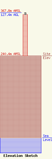
Site Elevation: 240.4 meters (789 ft) |
| Height of Structure: 122.2 meters (401 feet) |
| Overall Height Above Ground: 127.4 meters (418 feet) |
| Overall Height Above Mean Sea Level: 367.8 meters (1207 feet) |
| Owner Info | EIP Holdings II, LLC
Two Allegheny Center, Nova Tower 2
PITTSBURGH, PA 15212
(844) 282-7748
regulatory@everestinfrastructure.com |
| Contact Info | EIP Holdings II, LLC
Two Allegheny Center, Nova Tower 2
Pittsburgh, PA 15212
Justin Burgess
(844) 282-7748
regulatory@everestinfrastructure.com |
