|
|
Antenna Structure Registration 1008934 |
 |
Registration Info | Registration Number: 1008934 |
| File Number: A1049609 |
| FAA Study: 00-AGL-4029-OE |
| FAA Issue Date: 08/01/2000 |
| Status: Granted |
| Date Constructed: 04/25/1984 |
| FAA EMI: N |
| NEPA: N |
Structure Info
| Structure Type: TOWER |
| Structure Coordinates: 39-47-56.8 N 89-26-46.1 W (NAD 83) |
| Structure Coordinates: 39-47-56.6 N 89-26-45.8 W (Converted to NAD 27) |
| Structure Address: 2.6 Mi Sw |
| Structure City: Mechanicsburg, IL |
| Structure County: Sangamon County |
| Painting & Lighting Info |
FAA Circular #: 70/7460-1K |
FAA Chapters: 4, 7, 12 |
Remarks: PRIOR FAA 83-AGL-1228-OE |
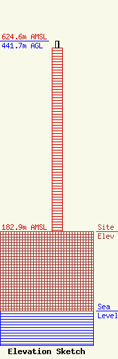
| Elevation Info |
Site Elevation: 182.9 meters (600 ft) |
| Height of Structure: 426.7 meters (1400 feet) |
| Overall Height Above Ground: 441.7 meters (1449 feet) |
| Overall Height Above Mean Sea Level: 624.6 meters (2049 feet) |
| Owner Info | GOCOM Media of Illinois, LLC
400 Main St.
Hilton Head, SC 29926
(843) 342-4405
ricgorman@gmail.com |
| Contact Info | GOCOM Media of Illinois, LLC
3003 Old Rochester Road
Springfield, IL 62703
Jack Richardson
(217) 523-8855
jrichardson@foxillinois.com |
