|
|
Antenna Structure Registration 1009074 |
 |
Registration Info | Registration Number: 1009074 |
| File Number: A1379009 |
| FAA Study: 2005-AGL-3540-OE |
| FAA Issue Date: 08/29/2005 |
| Status: Constructed |
| Date Constructed: 09/20/1991 |
| FAA EMI: N |
| NEPA: N |
Structure Info
|
| Structure Coordinates: 42-19-20.7 N 88-57-14.4 W (NAD 83) |
| Structure Coordinates: 42-19-20.6 N 88-57-14.0 W (Converted to NAD 27) |
| Structure Address: 8330 Riverside Blvd |
| Structure City: Loves Park, IL |
| Structure County: Winnebago County |
| Painting & Lighting Info |
FCC Paragraph(s): A1, H |
Remarks: PRIOR STUDY 1990-AGL-2125-OE |
Remarks: Continue As Is OM&L = 24-HR MED-STROBES |
Remarks: PRIOR STUDY 1990-AGL-2125-OE |
| Elevation Info |
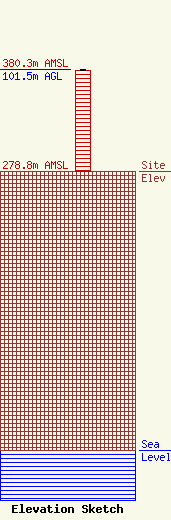
Site Elevation: 278.8 meters (915 ft) |
| Height of Structure: 100.5 meters (330 feet) |
| Overall Height Above Ground: 101.5 meters (333 feet) |
| Overall Height Above Mean Sea Level: 380.3 meters (1248 feet) |
| Owner Info | GTC Uno, LLC
PO Box 2359
Ponte Vedra Beach, FL 32004
(844) 482-8977
regulatory@gtctowers.com |
| Contact Info | GTC Uno, LLC
PO Box 2359
Ponte Vedra Beach, FL 32004
(844) 482-8977
regulatory@gtctowers.com |
