|
|
Antenna Structure Registration 1009325 |
 |
Registration Info | Registration Number: 1009325 |
| File Number: A0078028 |
| FAA Study: 96-ASW-1118-OE |
| FAA Issue Date: 08/08/1996 |
| Status: Granted |
| NEPA: N |
Structure Info
| Structure Type: TOWER |
| Structure Coordinates: 35-53-29.0 N 91-43-32.0 W (NAD 83) |
| Structure Coordinates: 35-53-28.7 N 91-43-31.5 W (Converted to NAD 27) |
| Structure Address: Land Section 3 Twn 14 - N Range 7 - W 8.4 Km Sw |
| Structure City: Sandtown, AR |
| Structure County: Independence County |
| Painting & Lighting Info |
FAA Circular #: 70/7460-1H |
FAA Chapters: 3, 4, 5, 13 |
| Elevation Info |
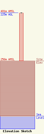
Site Elevation: 256 meters (840 ft) |
| Height of Structure: 224 meters (735 feet) |
| Overall Height Above Ground: 225 meters (738 feet) |
| Overall Height Above Mean Sea Level: 481 meters (1578 feet) |
| Owner Info | WRD ENTERTAINMENT INC
2077
BATESVILLE, AR 72503
(501) 793-4196
|
