|
|
Antenna Structure Registration 1009377 |
 |
Registration Info | Registration Number: 1009377 |
| File Number: A0011152 |
| FAA Study: 79-GL-1044-OE |
| FAA Issue Date: 12/12/1979 |
| Status: Constructed |
| Date Constructed: 01/01/1980 |
| NEPA: N |
Structure Info
| Structure Type: TOWER |
| Structure Coordinates: 40-37-44.0 N 89-34-12.0 W (NAD 83) |
| Structure Coordinates: 40-37-43.9 N 89-34-11.6 W (Converted to NAD 27) |
| Structure Address: 2600 Cole St |
| Structure City: East Peoria, IL |
| Structure County: Tazewell County |
| Painting & Lighting Info |
FAA Circular #: |
FCC Paragraph(s): 1, 3, 4, 13, 21 |
Remarks: RED LIGHTS/PAINT |
| Elevation Info |
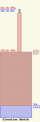
Site Elevation: 228.6 meters (750 ft) |
| Height of Structure: 165.8 meters (544 feet) |
| Overall Height Above Ground: 182.3 meters (598 feet) |
| Overall Height Above Mean Sea Level: 410.9 meters (1348 feet) |
| Owner Info | ILLINOIS VALLEY PUBLIC TELECOMMUNICATIONS CORPORATION DBA = WTVP TV
1501 W BRADLEY AVE
PEORIA, IL 61625
(309) 677-4747
WTVPMAIL@WTVP.PBS.ORG |
