|
|
Antenna Structure Registration 1009518 |
 |
Registration Info | Registration Number: 1009518 |
| File Number: A0784548 |
| FAA Study: 2012-AGL-7083-OE |
| FAA Issue Date: 08/29/2012 |
| Status: Constructed |
| Date Constructed: 09/18/1993 |
| FAA EMI: N |
| NEPA: N |
Structure Info
| Structure Type: GTOWER |
| Structure Coordinates: 40-6-36.0 N 91-1-48.9 W (NAD 83) |
| Structure Coordinates: 40-06-35.8 N 91-01-48.4 W (Converted to NAD 27) |
| Structure Address: .5 Mi W |
| Structure City: Golden, IL |
| Structure County: Adams County |
| Painting & Lighting Info |
FAA Circular #: 70/7460-1K |
FAA Chapters: 4, 8, 12 |
Remarks: PRIOR STUDY 2012-AGL-4720-OE |
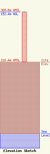
| Elevation Info |
Site Elevation: 216.4 meters (710 ft) |
| Height of Structure: 152.4 meters (500 feet) |
| Overall Height Above Ground: 152.4 meters (500 feet) |
| Overall Height Above Mean Sea Level: 368.8 meters (1210 feet) |
| Owner Info | ADAMS TELEPHONE COOPERATIVE
217
GOLDEN, IL 62339
(217) 696-4411
jimbroemmer@adams.net |
| Contact Info | Adams Telephone Co-Operative
405 Emminga Rd
217
Golden, IL 62339
Jim Broemmer
(217) 696-4411
jimbroemmer@adams.net |
