|
|
Antenna Structure Registration 1009521 |
 |
Registration Info | Registration Number: 1009521 |
| File Number: A0011327 |
| FAA Study: 81-GL-889-OE |
| FAA Issue Date: 10/26/1981 |
| Status: Constructed |
| Date Constructed: 01/01/1981 |
| NEPA: N |
Structure Info
| Structure Type: 2TA2 |
| Structure Coordinates: 42-18-46.0 N 89-35-36.0 W (NAD 83) |
| Structure Coordinates: 42-18-45.9 N 89-35-35.6 W (Converted to NAD 27) |
| Structure Address: Twr 2 - 834 North Tower Rd |
| Structure City: Freeport, IL |
| Structure County: Stephenson County |
| Painting & Lighting Info |
FCC Paragraph(s): 1, 3, 12, 21 |
Remarks: RED LIGHTS/PAINT |
| Elevation Info |
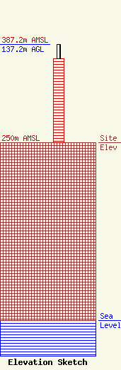
Site Elevation: 250 meters (820 ft) |
| Height of Structure: 118 meters (387 feet) |
| Overall Height Above Ground: 137.2 meters (450 feet) |
| Overall Height Above Mean Sea Level: 387.2 meters (1270 feet) |
| Owner Info | CONNOISSEUR COMMUNICATIONS OF ROCKFORD, L.P.
3901 BRENDENWOOD ROAD
ROCKFORD, IL 61107
(815) 399-2233
DAVERRC@AOL.COM |
