|
|
Antenna Structure Registration 1009524 |
 |
Registration Info | Registration Number: 1009524 |
| File Number: A1118200 |
| FAA Study: 2011-ASW-4518-OE |
| FAA Issue Date: 09/02/2011 |
| Status: Constructed |
| Date Constructed: 01/01/1947 |
| FAA EMI: N |
| NEPA: N |
Structure Info
| Structure Type: 3TA1 |
| Structure Coordinates: 36-8-46.8 N 95-48-29.5 W (NAD 83) |
| Structure Coordinates: 36-08-46.4 N 95-48-28.5 W (Converted to NAD 27) |
| Structure Address: Sw Tower 15050 E 11th St |
| Structure City: Tulsa, OK |
| Structure County: Tulsa County |
| Painting & Lighting Info |
FAA Circular #: 70/7460-1K |
FAA Chapters: 3, 4, 5, 12 |
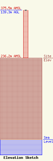
| Elevation Info |
Site Elevation: 236.2 meters (775 ft) |
| Height of Structure: 138.4 meters (454 feet) |
| Overall Height Above Ground: 139.3 meters (457 feet) |
| Overall Height Above Mean Sea Level: 375.5 meters (1232 feet) |
| Owner Info | Griffin Licensing, L.L.C.
7401 N. Kelley Avenue
Oklahoma City, OK 73111
(405) 841-9106
trevor.wiseman@griffin.news |
| Contact Info | Wilkinson Barker Knauer, LLP
1800 M Street, N.W.
Washington, DC 20036
David O'Connor
(202) 783-4141
doconnor@wbklaw.com |
