|
|
Antenna Structure Registration 1009650 |
 |
Registration Info | Registration Number: 1009650 |
| File Number: A1384278 |
| FAA Study: 2012-AGL-2897-OE |
| FAA Issue Date: 05/04/2012 |
| Status: Constructed |
| Date Constructed: 06/01/1953 |
| FAA EMI: N |
| NEPA: N |
Structure Info
|
| Structure Coordinates: 39-49-28.6 N 88-58-3.6 W (NAD 83) |
| Structure Coordinates: 39-49-28.5 N 88-58-03.3 W (Converted to NAD 27) |
| Structure Address: 904 South Side Drive |
| Structure City: Decatur, IL |
| Structure County: Macon County |
| Painting & Lighting Info |
FCC Paragraph(s): 1, 3, 5, 14, 21 |
Remarks: Continue As Is OM&L = PAINT/RED LIGHTS |
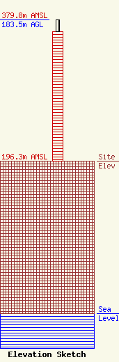
| Elevation Info |
Site Elevation: 196.3 meters (644 ft) |
| Height of Structure: 167.6 meters (550 feet) |
| Overall Height Above Ground: 183.5 meters (602 feet) |
| Overall Height Above Mean Sea Level: 379.8 meters (1246 feet) |
| Owner Info | Gray Local Media, Inc.
4370 Peachtree Road, NE
Atlanta, GA 30319
(404) 266-8333
legalnotices@graymedia.com |
| Contact Info | Gray Local Media, Inc.
4370 Peachtree Road NE
Atlanta, GA 30319
Engineering Department
(404) 266-8333
legalnotices@graymedia.com |
