|
|
Antenna Structure Registration 1009651 |
 |
Registration Info | Registration Number: 1009651 |
| File Number: A1384279 |
| FAA Study: 2012-AGL-2898-OE |
| FAA Issue Date: 05/03/2012 |
| Status: Constructed |
| Date Constructed: 10/01/1980 |
| FAA EMI: N |
| NEPA: N |
Structure Info
|
| Structure Coordinates: 39-57-8.6 N 88-49-56.6 W (NAD 83) |
| Structure Coordinates: 39-57-08.5 N 88-49-56.3 W (Converted to NAD 27) |
| Structure Address: Jordan Road 0.4 Mile West Of Interstate 72, Macon County |
| Structure City: Argenta, IL |
| Structure County: Macon County |
| Painting & Lighting Info |
FAA Circular #: 70/7460-1K |
FAA Chapters: 4, 7, 12 |
Remarks: PRIOR STUDY 2007-AGL-7089-OE. Continue As Is OM&L = 24-HR HI-STROBES |
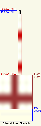
| Elevation Info |
Site Elevation: 209.1 meters (686 ft) |
| Height of Structure: 378.9 meters (1243 feet) |
| Overall Height Above Ground: 400.5 meters (1314 feet) |
| Overall Height Above Mean Sea Level: 609.6 meters (2000 feet) |
| Owner Info | Gray Local Media, Inc.
4370 Peachtree Road, NE
Atlanta, GA 30319
(404) 266-8333
legalnotices@graymedia.com |
| Contact Info | Gray Local Media, Inc.
4370 Peachtree Road NE
Atlanta, GA 30319
Engineering Department
(404) 266-8333
legalnotices@graymedia.com |
