|
|
Antenna Structure Registration 1009813 |
 |
Registration Info | Registration Number: 1009813 |
| File Number: A0565045 |
| FAA Study: 80-ARM-347-OE |
| Status: Constructed |
| Date Constructed: 09/01/1982 |
| FAA EMI: N |
| NEPA: N |
Structure Info
| Structure Type: TOWER |
| Structure Coordinates: 44-14-35.0 N 105-32-21.0 W (NAD 83) |
| Structure Coordinates: 44-14-35.1 N 105-32-19.0 W (Converted to NAD 27) |
| Structure Address: Sw 1/4 Of Sect 8 T49n R72w Campbell County |
| Structure City: Gillette, WY |
| Structure County: Campbell County |
| Painting & Lighting Info |
FAA Circular #: 70/7460-1F |
FAA Chapters: 3, 5, 9 |
| Elevation Info |
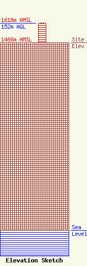
Site Elevation: 1466 meters (4810 ft) |
| Height of Structure: 151 meters (495 feet) |
| Overall Height Above Ground: 152 meters (499 feet) |
| Overall Height Above Mean Sea Level: 1618 meters (5308 feet) |
| Owner Info | Legend Communications of Wyoming, LLC
6805 Douglas Legum Drive, Suite 100
1210
Elkridge, MD 21075
(410) 799-1740
larry@patcomm.com |
| Contact Info | Sciarrino & Associates, PLLC
5425 Tree Line Drive
Centreville, VA 20120
Dawn Sciarrino
(703) 830-1679
dawn@sciarrinolaw.com |
