|
|
Antenna Structure Registration 1009985 |
 |
Registration Info | Registration Number: 1009985 |
| File Number: A1085079 |
| FAA Study: 2017-AWP-6247-OE |
| FAA Issue Date: 06/14/2017 |
| Status: Constructed |
| Date Constructed: 08/24/2001 |
Structure Info
| Structure Type: LTOWER |
| Structure Coordinates: 36-0-36.4 N 115-0-22.7 W (NAD 83) |
| Structure Coordinates: 36-00-36.5 N 115-00-19.7 W (Converted to NAD 27) |
| Structure Address: Black Mountain Road .7 Miles West Of I-515 ( Black Mountain Twr 4, 90348) |
| Structure City: Henderson, NV |
| Structure County: Clark County |
| Painting & Lighting Info |
FAA Circular #: 70/7460-1L |
FAA Chapters: 4, 6, 12 |
Remarks: PRIOR STUDY 2016-AWP-4219-OE |
| Elevation Info |
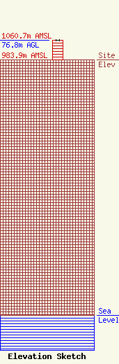
Site Elevation: 983.9 meters (3228 ft) |
| Height of Structure: 75.3 meters (247 feet) |
| Overall Height Above Ground: 76.8 meters (252 feet) |
| Overall Height Above Mean Sea Level: 1060.7 meters (3480 feet) |
| Owner Info | American Towers LLC
10 Presidential Way
Woburn, MA 01801
(678) 564-3236
FAA-FCC@americantower.com |
| Contact Info | American Tower, LLC
10 Presidential Way
Woburn, MA 01801
(678) 564-3236
FAA-FCC@americantower.com |
