|
|
Antenna Structure Registration 1010348 |
 |
Registration Info | Registration Number: 1010348 |
| File Number: A0462427 |
| FAA Study: 96-ASO-5412-OE |
| FAA Issue Date: 12/10/1996 |
| Status: Constructed |
| Date Constructed: 01/01/1978 |
| FAA EMI: N |
| NEPA: N |
Structure Info
| Structure Type: TOWER |
| Structure Coordinates: 35-40-6.0 N 78-31-58.0 W (NAD 83) |
| Structure Coordinates: 35-40-05.4 N 78-31-59.0 W (Converted to NAD 27) |
| Structure Address: Near Hwy 70 4 Mi Nw |
| Structure City: Clayton, NC |
| Structure County: Wake County |
| Painting & Lighting Info |
FAA Circular #: 70/7460-1J |
FAA Chapters: 4, 7, 13 |
| Elevation Info |
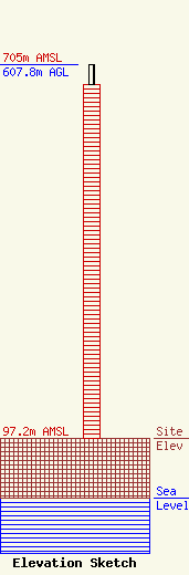
Site Elevation: 97.2 meters (319 ft) |
| Height of Structure: 574.8 meters (1886 feet) |
| Overall Height Above Ground: 607.8 meters (1994 feet) |
| Overall Height Above Mean Sea Level: 705 meters (2313 feet) |
| Owner Info | WTVD Television, LLC
77 West 66th Street, 16th Floor
New York, NY 10023-6298
(212) 456-7777
|
