|
|
Antenna Structure Registration 1010438 |
 |
Registration Info | Registration Number: 1010438 |
| File Number: A1194702 |
| FAA Study: 1-OE-2182 |
| FAA Issue Date: 12/16/1962 |
| Status: Constructed |
| Date Constructed: 09/01/1956 |
| FAA EMI: N |
| NEPA: N |
Structure Info
| Structure Type: TOWER |
| Structure Coordinates: 42-6-20.2 N 76-52-16.0 W (NAD 83) |
| Structure Coordinates: 42-06-19.9 N 76-52-17.1 W (Converted to NAD 27) |
| Structure Address: Hawley Hill |
| Structure City: Elmira, NY |
| Structure County: Chemung County |
| Painting & Lighting Info |
FAA Chapters: NONE |
Remarks: NO OM&L BASED SHIELDING BY TALLER STRUCTURE. |
| Elevation Info |
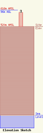
Site Elevation: 520 meters (1706 ft) |
| Height of Structure: 83 meters (272 feet) |
| Overall Height Above Ground: 96 meters (315 feet) |
| Overall Height Above Mean Sea Level: 616 meters (2021 feet) |
| Owner Info | Nexstar Media Inc.
545 E. John Carpenter Freeway
Irving, TX 75062
(972) 373-8800
jasroberts@nexstar.tv |
| Contact Info | Nexstar Media Inc.
545 E. John Carpenter Freeway
Irving, TX 75062
Jason Roberts
(972) 373-8800
jasroberts@nexstar.tv |
