|
|
Antenna Structure Registration 1010492 |
 |
Registration Info | Registration Number: 1010492 |
| File Number: A0012562 |
| FAA Study: 95-ASW-2141-OE |
| Status: Terminated |
| NEPA: N |
Structure Info
| Structure Type: POLE |
| Structure Coordinates: 34-46-24.0 N 92-21-34.0 W (NAD 83) |
| Structure Coordinates: 34-46-23.7 N 92-21-33.4 W (Converted to NAD 27) |
| Structure Address: 7618 T St |
| Structure City: Little Rock, AR |
| Structure County: Pulaski County |
| Painting & Lighting Info |
| Elevation Info |
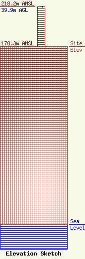
Site Elevation: 178.3 meters (585 ft) |
| Height of Structure: 39.9 meters (131 feet) |
| Overall Height Above Ground: 39.9 meters (131 feet) |
| Overall Height Above Mean Sea Level: 218.2 meters (716 feet) |
| Owner Info | AT&T WIRELESS SERVICES INC
1150 CONNECTICUT AVE NW 4TH FL
WASHINGTON, DC 20036
(202) 223-9222
ESTHER.HILLIARD@ATTWS.COM |
