|
|
Antenna Structure Registration 1010560 |
 |
Registration Info | Registration Number: 1010560 |
| File Number: A1309481 |
| FAA Study: 2024-AWP-13069-OE |
| FAA Issue Date: 03/04/2025 |
| Status: Constructed |
| Date Constructed: 01/01/1974 |
| NEPA: N |
Structure Info
| Structure Type: GTOWER |
| Structure Coordinates: 37-51-0.4 N 122-11-33.6 W (NAD 83) |
| Structure Coordinates: 37-51-00.7 N 122-11-29.7 W (Converted to NAD 27) |
| Structure Address: Highest Point Grizzly Peak Blvd/skyline Blvd. (8240) |
| Structure City: Orinda, CA |
| Structure County: Contra Costa County |
| Painting & Lighting Info |
FAA Circular #: 70/7460-1K |
FAA Chapters: 3, 4, 5, 12 |
Remarks: PRIOR STUDIES 2013-AWP-3640-OE / 2024-AWP-6140-OE |
Remarks: OM&L to remain the same as prior studies = PAINT/RED LIGHTS |
Remarks: PRIOR STUDIES 2013-AWP-3640-OE / 2024-AWP-6140-OE |
Remarks: OM&L to remain the same as prior studies = PAINT/RED LIGHTS |
| Elevation Info |
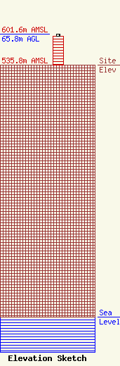
Site Elevation: 535.8 meters (1758 ft) |
| Height of Structure: 61.3 meters (201 feet) |
| Overall Height Above Ground: 65.8 meters (216 feet) |
| Overall Height Above Mean Sea Level: 601.6 meters (1974 feet) |
| Owner Info | American Towers LLC
10 Presidential Way
Woburn, MA 01801
(781) 926-4500
faa-fcc@americantower.com |
| Contact Info | American Towers LLC
10 Presidential Way
Woburn, MA 01801
(781) 926-4500
faa-fcc@americantower.com |
