|
|
Antenna Structure Registration 1010625 |
 |
Registration Info | Registration Number: 1010625 |
| File Number: A0012725 |
| FAA Study: 97-AWP-1089-OE |
| FAA Issue Date: 04/28/1997 |
| Status: Cancelled |
| NEPA: N |
Structure Info
| Structure Type: POLE |
| Structure Coordinates: 34-6-30.0 N 118-3-29.0 W (NAD 83) |
| Structure Coordinates: 34-06-30.0 N 118-03-25.8 W (Converted to NAD 27) |
| Structure Address: 5938 Kauffman Ave. |
| Structure City: Temple City, CA |
| Structure County: Los Angeles County |
| Painting & Lighting Info |
FAA Circular #: 70/7460-1J |
FAA Chapters: 4, 5, 13 |
Remarks: PRIOR STUDY 96-AWP-1473-OE. |
| Elevation Info |
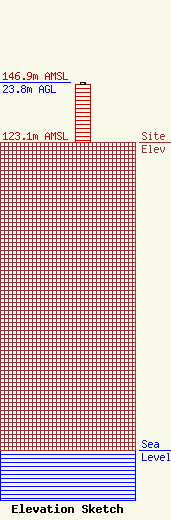
Site Elevation: 123.1 meters (404 ft) |
| Height of Structure: 23.2 meters (76 feet) |
| Overall Height Above Ground: 23.8 meters (78 feet) |
| Overall Height Above Mean Sea Level: 146.9 meters (482 feet) |
| Owner Info | LOS ANGELES CELLULAR TELEPHONE COMPANY DBA = L.A. CELLULAR
17785 CENTER COURT DRIVE, NORTH
CERRITOS, CA 90703-8575
(310) 468-6035
MARAMBURO@AOL.COM |
