|
|
Antenna Structure Registration 1010845 |
 |
Registration Info | Registration Number: 1010845 |
| File Number: A0078232 |
| FAA Study: 96-AGL-3949-OE |
| Status: Constructed |
| Date Constructed: 01/01/1950 |
| NEPA: N |
Structure Info
| Structure Type: 2TA1 |
| Structure Coordinates: 43-48-4.0 N 83-1-23.0 W (NAD 83) |
| Structure Coordinates: 43-48-03.9 N 83-01-23.2 W (Converted to NAD 27) |
| Structure Address: Twr 1 935 S Van Dyke Rd |
| Structure City: Bad Axe, MI |
| Structure County: Huron County |
| Painting & Lighting Info |
FCC Paragraph(s): 1, 3, 11, 21 |
| Elevation Info |
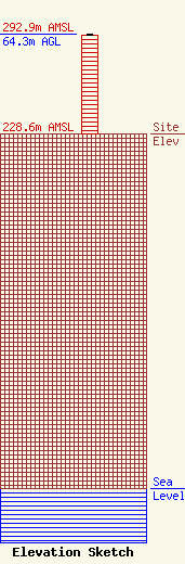
Site Elevation: 228.6 meters (750 ft) |
| Height of Structure: 63.4 meters (208 feet) |
| Overall Height Above Ground: 64.3 meters (211 feet) |
| Overall Height Above Mean Sea Level: 292.9 meters (961 feet) |
| Owner Info | THUMB BROADCASTING INC
935 S VAN DYKE RD
BAD AXE, MI 48413
(517) 269-9931
|
