|
|
Antenna Structure Registration 1011168 |
 |
Registration Info | Registration Number: 1011168 |
| File Number: A1046485 |
| Status: Constructed |
| Date Constructed: 01/01/1976 |
| FAA EMI: N |
| NEPA: N |
Structure Info
| Structure Type: 4TA2 |
| Structure Coordinates: 42-35-23.0 N 71-49-40.0 W (NAD 83) |
| Structure Coordinates: 42-35-22.7 N 71-49-41.7 W (Converted to NAD 27) |
| Structure Address: Alpine Rd |
| Structure City: Fitchburg, MA |
| Structure County: Worcester County |
| Painting & Lighting Info |
FCC Paragraph(s): 1, 2, 11, 21 |
| Elevation Info |
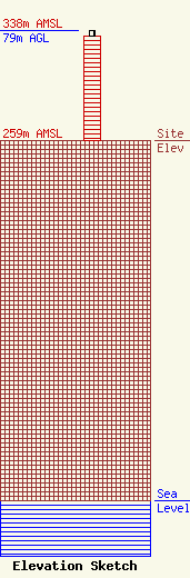
Site Elevation: 259 meters (850 ft) |
| Height of Structure: 75 meters (246 feet) |
| Overall Height Above Ground: 79 meters (259 feet) |
| Overall Height Above Mean Sea Level: 338 meters (1109 feet) |
| Owner Info | Horizon Christian Fellowship
356 Broad Street
Fitchburg, MA 01420
(978) 665-9111
george.small@horizonfitchburg.org |
| Contact Info | Fletcher, Heald & Hildreth, PLC
1300 N 17th Street
Arlington, VA 22209
Matthew McCormick
(703) 812-0438
mccormick@fhhlaw.com |
