|
|
Antenna Structure Registration 1011182 |
 |
Registration Info | Registration Number: 1011182 |
| File Number: A1194705 |
| FAA Study: 2017-AGL-19747-OE |
| FAA Issue Date: 12/06/2017 |
| Status: Constructed |
| Date Constructed: 03/13/2020 |
| NEPA: N |
Structure Info
| Structure Type: GTOWER |
| Structure Coordinates: 41-19-39.0 N 90-22-46.0 W (NAD 83) |
| Structure Coordinates: 41-19-38.9 N 90-22-45.5 W (Converted to NAD 27) |
| Structure Address: 1 3/4 Mi S |
| Structure City: Orion, IL |
| Structure County: Henry County |
| Painting & Lighting Info |
FAA Circular #: 70/7460-1G |
FAA Chapters: 3, 4, 5, 9 |
Remarks: PRIOR STUDY 1998-AGL-18-OE |
Remarks: OM&L to remain the same as prior study = PAINT/RED LIGHTS |
Remarks: PRIOR STUDY 1998-AGL-18-OE |
Remarks: OM&L to remain the same as prior study = PAINT/RED LIGHTS |
| Elevation Info |
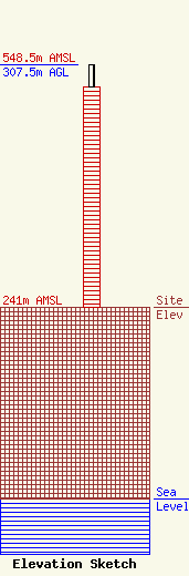
Site Elevation: 241 meters (791 ft) |
| Height of Structure: 279 meters (915 feet) |
| Overall Height Above Ground: 307.5 meters (1009 feet) |
| Overall Height Above Mean Sea Level: 548.5 meters (1800 feet) |
| Owner Info | Nexstar Media Inc.
545 E. John Carpenter Freeway
Irving, TX 75062
(972) 373-8800
jasroberts@nexstar.tv |
| Contact Info | Nexstar Media Inc.
545 E. John Carpenter Freeway
Irving, TX 75062
Jason Roberts
(972) 373-8800
jasroberts@nexstar.tv |
