|
|
Antenna Structure Registration 1011183 |
 |
Registration Info | Registration Number: 1011183 |
| File Number: A1194706 |
| Status: Constructed |
| Date Constructed: 01/01/1950 |
| FAA EMI: N |
| NEPA: N |
Structure Info
| Structure Type: TOWER |
| Structure Coordinates: 41-30-37.0 N 90-34-27.0 W (NAD 83) |
| Structure Coordinates: 41-30-36.9 N 90-34-26.5 W (Converted to NAD 27) |
| Structure Address: 231 18th St |
| Structure City: Rock Island, IL |
| Structure County: Rock Island County |
| Painting & Lighting Info |
FCC Paragraph(s): 1, 3, 4, 13, 21 |
| Elevation Info |
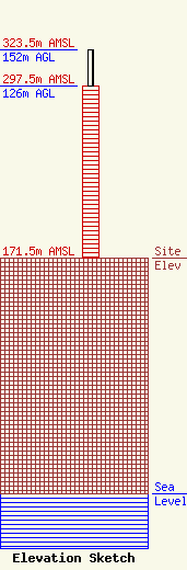
Site Elevation: 171.5 meters (563 ft) |
| Height of Structure: 126 meters (413 feet) |
| Overall Height Above Ground: 152 meters (499 feet) |
| Overall Height Above Mean Sea Level: 323.5 meters (1061 feet) |
| Owner Info | Nexstar Media Inc.
545 E. John Carpenter Freeway
Irving, TX 75062
(972) 373-8800
jasroberts@nexstar.tv |
| Contact Info | Nexstar Media Inc.
545 E. John Carpenter Freeway
Irving, TX 75062
Jason Roberts
(972) 373-8800
jasroberts@nexstar.tv |
