|
|
Antenna Structure Registration 1011236 |
 |
Registration Info | Registration Number: 1011236 |
| File Number: A1116431 |
| FAA Study: 2018-AWP-10683-OE |
| FAA Issue Date: 09/26/2018 |
| Status: Constructed |
| Date Constructed: 10/04/1995 |
| NEPA: N |
Structure Info
| Structure Type: POLE |
| Structure Coordinates: 34-7-12.3 N 118-3-51.5 W (NAD 83) |
| Structure Coordinates: 34-07-12.3 N 118-03-48.3 W (Converted to NAD 27) |
| Structure Address: 9501 Lemon Street (426090) |
| Structure City: Temple City, CA |
| Structure County: Los Angeles County |
| Painting & Lighting Info |
FAA Chapters: NONE |
Remarks: PRIOR STUDY 2002-AWP-3755-OE |
| Elevation Info |
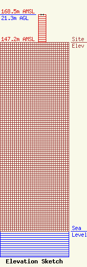
Site Elevation: 147.2 meters (483 ft) |
| Height of Structure: 21.3 meters (70 feet) |
| Overall Height Above Ground: 21.3 meters (70 feet) |
| Overall Height Above Mean Sea Level: 168.5 meters (553 feet) |
| Owner Info | Los Angeles SMSA Limited Partnership
5055 North Point Pkwy
Alpharetta, GA 30022
(770) 797-1070
NetworkRegulatory@VerizonWireless.com |
| Contact Info | Los Angeles SMSA Limited Partnership
5055 North Point Pkwy
Alpharetta, GA 30022
Regulatory Manager
(770) 797-1070
NetworkRegulatory@VerizonWireless.com |
